Our last day in the Lake District!
We had a lovely breakfast in our B&B, Noran Bank Farm, with a couple from Australia who had slept in the room next to ours. Marilyn and Jack are a retired couple who enjoy hiking trails all over the world. They told us about some of the more beautiful longer trails in Australia, and I mentally added more adventures to my bucket list.
The girls and I hike fairly quickly, so we took the lead when we all started out and were soon far ahead. We would see Marilyn and Jack again later in the day, though.
Walking out of Patterdale...


There is only supposed to be one major climb of the day on this stage. Kidsty Pike is the goal, and the way there is supposed to be straightforward. The first part of the climb was...we made it up to Angle Tarn well enough...


There's Angle Tarn...


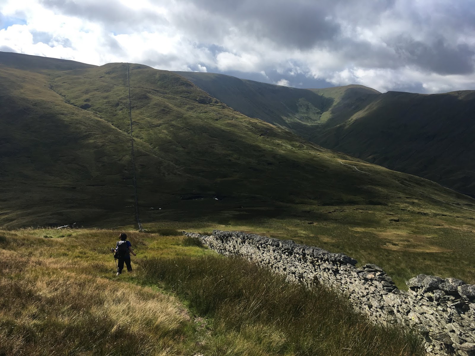
On our edition of Stedman's guidebook, there aren't any intersecting paths past Angle Tarn until you're almost at Kidsty Pike. However, there comes a point where there are two paths that diverge, and both go up and don't look like they will go off in two largely different directions. At this point, there were hikers behind us and another hiker hanging out at that junction taking a water break. The fellow drinking water was a young man from Ireland, and he was using a GPS. His GPS didn't seem to differentiate between the two ways forward, and the guidebook makes no mention of this section, and both paths look equally well-worn. The girls and I assumed both paths would join together again once over a little bump or two (WRONG), so we shrugged and took the left path (THIS IS THE WRONG WAY -- TAKE THE PATH ON THE RIGHT TO GO THE RIGHT WAY!!!). The fellow joined us, though I warned him were were guessing now and didn't really know which way was correct. Off we went, and we were luckily the day was clear and the weather was beautiful.

The guidebook mentions that the path goes to the left of a stone wall for a time, so I thought we had made the right choice, though I did notice other details of the book weren't matching up with the terrain ( we hadn't gone through a gap in a wall, for example)..

Kind of looks right...but....

We didn't know it at the time, but we headed up Rest Dodd, which is a mountain/hill northwest of Kidsty Pike. The fellow not far behind us walked confidently and followed his GPS.

This is the view from the top of Rest Dodd. From here, one can see water, which looks like it might be the water you are supposed to aim for as you descend Kidsty Pike (IT ISN'T).

The path no longer looked like the well-worn C2C path from that morning...but the C2C path sometimes doesn't look well worn at all (many times on earlier days, it looked like this). It was kind of going in the right direction..? At this point, I broke out my map and compass. I then realized that the body of water that had been in the right direction (southeast) during our ascent was now to the south/southwest of us, so that couldn't be where we were supposed to end up later in the day. This was definitely not the right mountain/hill. Looking at the map, I made an educated guess as to where we were, and the girls and I looked in the right direction toward Kidsty Pike. We saw a hill/mountain to the south/southeast of us that must have been The Knott, which the C2C crosses before reaching Kidsty Pike. We pointed this out to the Irish fellow who had joined us on this summit. He did not have a map, and his GPS apparently was not helping, so we explained what we were going to do and we headed in that direction. The Irish fellow followed at a distance behind us, and we kept checking behind us as we walked to make sure he was okay.
Crossing Rest Dodd...


We headed down, keeping our eyes on that path you can now clearly see in the distance. That's the C2C ascending The Knott.
We got to the bottom of the col, crossed a boggy field, and rejoined the C2C. After a climb of The Knott, there is another intersection -- this one is clearly marked, but since we were tired and a bit frustrated, we nearly missed it. A peak is straight ahead in the distance, but that's not Kidsty Pike. Turn left at the junction at The Knott and climb gently...then Kidsty Pike will be ahead of you as the path curves to the right.

The sky was darkening, so we chose to head down toward Haweswater before stopping to eat lunch.


We passed the Australian couple on our way down. Though we had taken the lead in the morning and had not seen them behind us all the way up the initial ascent, they had gotten ahead of us because they had taken the path to the right. They said they too were confused at that spot and had picked the right path out of luck. We walked with them until we got to a nice shady spot just before Haweswater, then we stopped for lunch while they continued on. The Irish fellow passed us while we were eating, which made us glad. Taking the wrong way up there could result in someone getting seriously lost for a very long time, and if bad weather comes in...well, I can see things going bad very quickly.
After lunch, we headed toward and along the water.


We passed Jack and Marilyn again, and we would see them again later...
Walking away from Haweswater and into the small town of Burbanks...


The C2C quickly diverts you from Burbanks and takes you through a field and along a pretty stream..


One is supposed to move away from the stream by taking a "right up side of field by gully." Okay...there were several spots that could have been the gully, and at no point was there an obvious path. We heard voices behind us as we were contemplating exactly where we were supposed to turn right and head up. Marilyn and Jack had caught up with us. We decided to tackle this section together. We headed up, realized fairly quickly we weren't in the right spot since we could not see the stone barn we were supposed to be heading toward, and then spread out a bit and crossed in a wide line until Jack spotted the barn. We had to climb over a barbed wire fence (this would not be the last time during this trip) to get back on track...there was a gap in the fence and a stone that made it possible for us to do so.
Looking down from where we were on the field...

From here until Shap Abbey, there are a ton of large fields to cross where you will use gates in the distance, overhead power lines, walls here and there, and ruined farm buildings to assess where you are. This is why the guidebook is so essential. The map, though quite helpful when lost in the hills so you can get a broad sense of where you are, would be useless here. There isn't enough detail at all; the scale is too large. The guidebook, however, has all the nitty gritty details that make route-finding possible. The five of us had a good time comparing notes, finding the right landmarks, joking about everything, and discussing various long-distance trails around the world. Marilyn and Jack were excellent company. The multitude of field photos below will hopefully give you a sense of how much ground there was to cover during this section. We had already had a tiring morning with all the hiking up right mountains and wrong mountains. The fields kept going on and on for us now -- the fun company of Marilyn and Jack kept our spirits up,though.


You can kind of see a path in the photo below. Often, that's as good as the path gets.

 |
| Photo taken by Marilyn |
 |
| Intrepid adventurers |


Holy cow, a signpost! It would be great if there were about 1000 more of these.


Shap Abbey! We could see it in the distance here.


Shap Abbey!

We took a fifteen-minute break to explore the Abbey. It was the last Abbey destroyed by King Henry VIII during his I-must-marry-Anne-Boleyn-so-I-must-create-The Church of England phase.


We then all headed on to Shap.


Not long after entering Shap, Marilyn and Jack found their B&B for the evening, so we said farewell. We were hoping to see them again at some point during the rest of the trip, but we didn't. Well, we ran into them at dinner one night at a restaurant, but we never saw them again on the actual trail. That was a shame, because we enjoyed hiking with them; hope they are having a great time right now on another trail as I write this. Happy hiking, fellow travelers.

Our home for the evening, the Greyhound Hotel, was at the far end of Shap.


This was our favorite place to stay, by the way. Excellent rooms that were the best priced on our journey. The food was fantastic, too -- though service was slow that evening because they had just reopened and a local event brought a hundred people over without the restaurant having any advanced notice. The service staff was friendly and fantastic though, and the food was worth the wait. I don't think there is normally a long wait for food -- I definitely recommend staying and eating here during your own C2C adventure.
Next post: Hiking Day #5: Shap to Orton.
No comments:
Post a Comment